
Weather in Val Thorens
Get the latest Val Thorens weather forecasts
Also see our Val Thorens Snow Report and be the first to know about properly big snowfalls.
Bordering both Switzerland and Italy, the French Alps are one of the principal mountain ranges in France; the others most notably being the Vosges in Alsace and Lorraine, the Pyrenees in the extreme south, the Massif Central and the Jura. The weather and climate of the French Alps and Jura tend to be very similar to that found in the Swiss Alps. These high mountain areas have their own distinctive climates, with heavier precipitation and generally colder temperatures than the rest of the country throughout the year. At elevations of 1,500m and above, almost all precipitation in winter falls as snow that will usually remain on the ground from November until as late as May or June, particularly in areas above 2,000m.
Mountain Climates
The Alps have a profound effect on our weather and climate as they act as a natural barrier on which large scale weather systems can be deflected, modified or even created anew. Mild, moist air reaches the mountains from the west; bitterly cold artic air comes down from the north; dry continental air - hot in summer and cold in winter – comes in from the east, and Mediterranean air arrives from the south; so it’s hardly surprising that the area has unpredicatable and rapidly changing weather patterns.
In summer, the Val Thorens climate is generally hot and sunny in the lower valleys and pleasantly cool higher up. The valleys accumulate the heat because the air remains in contact with the sheltered, sun drenched ground for longer and thus increases the air temperature. However, in winter, conditions are often reversed and these valleys become much chillier as the cold, dense air sinks down the mountainside to form a pool in the valley itself. This is why many alpine villages are built part way up the mountain rather than on the valley floors, so they benefit from pleasant summer breezes and make the most of winter sunshine.
Bands of high pressure often dominate the weather in winter and can cause temperature inversions, where cold air is trapped beneath warmer air. On these occasions it is common for fog to form in the pools of cold valley air which can sometimes persist for weeks on end and is very depressing! This is a phenomenon that is often seen when out skiing where thick cloud has sunk down into the valley whilst the pistes are bathed in sunshine and are wonderfully warm.
Altitude Effect
Variation in altitude also plays an important part in influencing the weather and climate of Val Thorens. Air temperature generally decreases by an average of 6.5°C per 1,000m of height gain, and as air is only heated by its contact with a ground surface, strong winds have usually swept the air away in the high mountains before it has had time to warm up. This means that it can feel relatively warm, even in sub-zero temperatures, if the sky is clear and the sun is shining, while a higher temperature can feel relatively cool if accompanied by a biting cold wind. The cold wind can also bring the added problems of wind burn and dehydration in the dry air.
Of course the thinner or less dense air found at altitude not only makes breathing more difficult, but it also affords less protection against UV radiation than at a lower altitude. Therefore the risk of sun burn is far greater (even on cloudy days) without adequate sun protection and the risk is multiplied further in snow covered areas as the sun's rays are reflected back off the snow.

Cloud Types
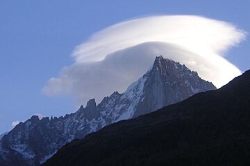
Lenticular Clouds
These wonderfully unique clouds form as a result of high winds that are forced upwards over an obstacle such as a hill or mountain. They are cumulus type clouds and are commonly associated with the strong winds of the foehn. The wind literally sculpts the cloud to create a smooth lens-shaped form that almost looks like a flying saucer. You can occasionally get multiple layers of lenticular clouds that form on the top of each wave. However, unlike other cloud types, lenticulars appear to be relatively stationery even though they form in high wind conditions. The air actually blows through the cloud, constantly renewing the water droplets within, which then evaporate as the air drops down the lee side of the mountain and thus gives the impression that the cloud is stationary. Lenticular cloud is very common on the top of Mont Blanc and is known as “L’âne de Mont Blanc”.
Thermals
Thermals are rising columns of warm air that form as the sun heats the ground. Some surfaces, such as water or green grass reflect much of the heat that hits them and so they are slow to warm up. Others, such as dry sand, tarmac or rocks absorb heat and therefore may warm up quite quickly. The difference in warming is also compounded by uneven ground and aspect (e.g. a south facing slope is warmer that a north facing one, and a westerly face is warmer in the evening). By heating a surface, the surrounding air warms up and expands and in doing so becomes less dense. If the sun continues to shine, then the “bubble” of warming air will get lighter and lighter causing it to rise away from the ground. As it rises up through the denser, cooler air around it, eventually it will reach a point where the surrounding air is the same temperature and it will stop and then gradually drop back down to earth and the process will begin again. A good visual of this process is a lava lamp – the lightbulb heats up the lava until it rises to the top of the lamp, where it cools down and drifts back to the bottom again.
The rising warm air very often contains more moisture that the surrounding cooler air and as the thermal rises it may reach condensation level or “dew-point” and a cloud is formed. The process of condensation is a heat-producing reaction and so the thermal receives a final boost of energy which is why cumulous clouds are heaped up, cauliflower shaped, and not just flat.
A thermal may be stopped at a low altitude if it passes through a layer of warmer air known as an “inversion”. They are so named because they are the “inverse” to the usual gradient of temperature reducing with height. As a result of these inversions, a thermal may rise quickly and then slow down or stop (depending on the strength and temperature of the thermal, relative to the warm layer) as it passes through these different layers. The inversion may be quite high meaning that thermals can still be felt even though they never reach a high enough altitude to form clouds. If they do, then towering cumulous clouds indicate a powerful thermal lift, small wispy ones (unless they are just forming) mean a weaker lift.
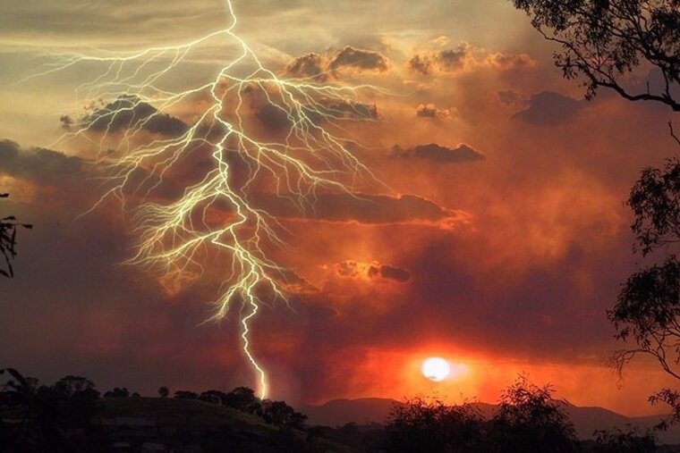
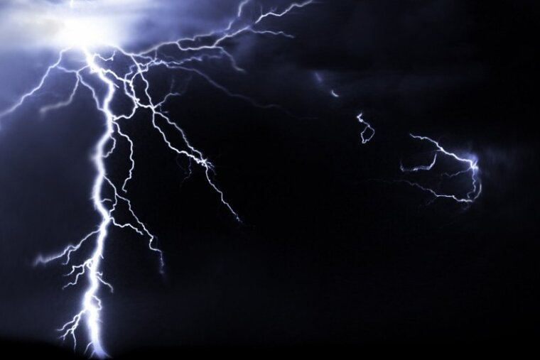
Thunder & Lightning
Thunderstorms are a common phenomenon in the mountains, especially in the summer, and there are very few more impressive backdrops in which to watch one. On a sunny summer’s day, the ground can often be hotter that the surrounding air and storms form when warm, moist air rises rapidly, and then cools and condenses into immense cumulonimbus thunderclouds. There is huge turbulence within these clouds and they become electrically charged as a result. Near the base, this charge is strongly negative, and the cloud becomes strongly positive in the upper reaches. Every so often the clouds discharge some of this electrical energy in the form of lightning. When that happens, the air surrounding the lightning rapidly expands and contracts causing vibrations or sound waves in the air. This, we hear as thunder. For years, you have probably counted the number of seconds between the lightning flash and the thunder rumble to work out how far away the storm is. Due to the enormous difference between the speed of sound and the speed of light, each second you count represents 300m.
Winds
A more widespread type of wind known as the foehn can affect large areas of the Alps under certain meteorological conditions. It is a warm, dry wind that blows down the lee (sheltered side) of mountains, bringing air of very low relative humidity. The föhn forms when a low pressure area pushes air up the windward (unsheltered) side of the mountain. As the air rises it cools and condenses into clouds when dewpoint is reached. This may lead to snow or rain on windward side of the mountain range. As the air mass descends the other side of the mountain it is warmed by compression at around 10ºC per 1,000m. At altitudes above 2,000m, this can mean that air is around 7ºC warmer in the valley on the lee side of the mountain range. With the onset of a Föhn wind temperature may rise as much as 15°C/27°F–20°C/36°F within an hour and such conditions may last for two or three days.
Föhn or foehn winds can be very strong, rolling back colder air masses and causing snow to be loaded onto lee slopes, forming hard snow slabs - a potential avalanche hazard. They are most noticeable in late winter and spring as they can lead to substantial thawing on lee slopes, hence the North American Indian name of Chinook or “snow eater”. Although it can blow in valleys on the southern side of the Alps, it is more severe on the northern side and blows particularly where valleys run from south to north.
Mountain Winds
Mountains often produce their own local winds, and wind currents can be shaped as they are forced to rise or are funnelled through valleys which greatly increase their strength. As an air mass descends a mountain slope it is compressed and becomes a warm dry wind. The effect is most noticeable in spring when these winds can melt snow very quickly. They are called Foehn winds in the Alps and Chinook ("snow-eaters") in North America. As well as causing unstable snow conditions and sometimes avalanches; they can also affect the mood of a person and general sense of wellbeing.
Other winds are truly local and are caused by a daily pattern of air-flow up and down valleys.
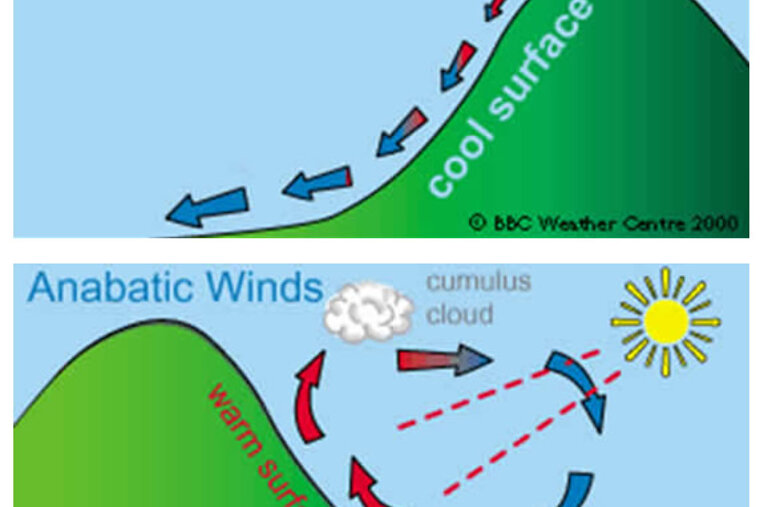
Katabatic winds are created by air flowing down an incline. In the Alps, they most commonly occur at night when cool air sinks down mountain slopes and valleys. These night time winds can be very cold if there are glaciers in the valley. A Katabatic wind can also be warm, for example, the Föhn wind. Anabatic winds or “valley breezes” occur when sun-warmed air rises and gently flows up mountain slopes and valleys.
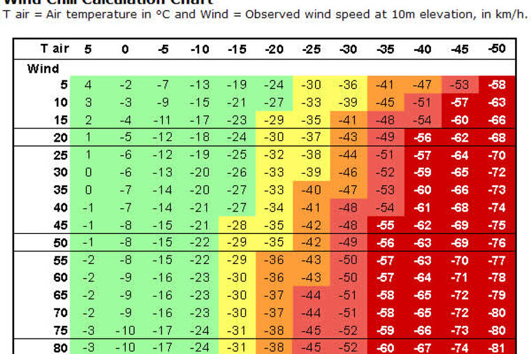
Wind chill
Anyone who has ever been stuck on a chairlift on a cold winter’s day knows that you feel even colder when the wind blows. We call the cooling sensation caused by the combined effect of temperature and wind - the 'wind chill'. The wind chill factor used by weather forecasters is designed to indicate the dangers posed by different combinations of wind and temperature on the bodies of humans and animals.
On a calm day, our bodies insulate us from the outside temperature by warming up a thin layer of air close to our skin, known as the boundary layer. When the wind blows, it takes this protective layer away - exposing our skin to the outside air. It takes energy for our bodies to warm up a new layer, and if each one keeps getting blown away, our skin temperature will drop, and we'll feel colder. Wind also makes us feel colder by evaporating any moisture on our skin - a process that draws more heat away from our bodies.
Studies show that when our skin is wet, it loses heat much faster than when it is dry. Interestingly humans don't sense the temperature of the air directly. When we feel that it's cold, we're actually sensing the temperature of our skin.
Safety Precautions
In a Thunderstorm
Whilst watching a thunderstorm from the comfort of your chalet is truly spectacular, being caught out in one whilst on the mountain is less funny. Although lightning can hardly be regarded as a major mountain hazard, every year it still claims the lives of two or three mountaineers. As more is understood about lightning and where it is likely to hit, certain simple precautions can be taken to avoid a strike.
During a storm, strikes tend to be concentrated on mountain tops or other such natural projections from the general surroundings. At the same time, since such points “service” a fairly wide area, there tends to be a shaded or relatively safe zone associated with them. The peak must be at least 7m high in order to create a relatively safe zone of roughly the same distance horizontally. However, it will not offer you any protection if you tuck yourself right in at its base which is the natural reaction, especially if it’s bucketing down with rain. In doing so, you are likely to offer yourself as a convenient alternative to the earth for electric currents as they shed from the peak. Leave at least 3m between you and your source of shelter and you should then be relatively safe from strikes in your vicinity.
Exactly the same argument applies to sheltering under large boulders. With reasonable waterproof clothing, remaining dry should not be a major problem and it is much safer to sit out in the open. Try to find a broken scree slope (preferably in a safe zone) and sit on top of a dry rope or rucksack with your knees up and your hands in your lap. Resist the temptation to support yourself with your hands or by leaning back, as the object of these precautions is to keep your points of contact with the ground as close together as possible. By sitting tucked up as described, any current flowing along the ground is likely to pass through a non-vital part of the body.
Where to get more weather forecasts
There are many different sources of weather information available in Val Thorens, many of which are also provided in English. If you have access to a television in your chalet/apartment, then the main French TV channels (TF1, TF2, M6) all have weather bulletins at regular intervals. Even if you don’t understand all that is said, TV forecasts and satellite images still give you a great visual for the general gist of the day’s weather.
Other useful sources include:
Telephone Forecasts
Again, these tend to be more on the general side but you can get them localised to your specific region or to the mountains by following the automated menu options. Resorts in the Northern Alps (Avoriaz, Morzine & Avoriaz) are in department 74, the 3 Valleys and the Tarentaise resorts are in department 73, and the Southern Alp resorts (Alpe d’Huez and 2 Alpes) are in department 38. Verbier is in the Valais region of Switzerland.
Swiss National Weather – Tel: 162
Snow Bulletin (in French) – Tel: +33 (0)892 68 10 20
Local Newspapers
Local publications vary from resort to resort but they all generally have a weather section with the forecast for the next few days. Le Dauphiné Libere is a national daily newspaper published per region with local weather information on the second back page.
Around Resort
There are usually a number of places in resort that post the weather forecast daily on their noticeboards. The most obvious ones to try are the Tourist Office, the CAF (Club Alpin Francais) bureau, the Mountain Guides office, Pharmacie, etc.
The Internet
If you have access to the internet during your stay then there are infinite numbers of websites that will give you an up to date forecast for your area. Here are some that we’ve found to be particularly useful:
Meteo France - Mountain weather and avalanche conditions bulletins (in French)
Meteo Swiss - Mountain weather and avalanche conditions in Switzerland (in French)
Snow-Forecast.com - Free snow forecasts for Val Thorens
Swiss Federal Institute for Snow and Avalanche Research - Swiss avalanche bulletins
Henry’s Avalanche Talks - popular avalanche training sessions based in French Alps as well as translation of current avalanche conditions
PisteHors.com - Backcountry Skiing and Snowboarding News in English for the French Alps. Excellent coverage of avalanche safety and advice.
French Avalanche Research Institute - Practical advice and information on avalanche awareness (in French)
Webcams
Not so much a weather forecasting tool, but certainly worth checking out Val Thorens webcams if you’re heading out for the day so you can see at a glance whether you’re going to need that extra layer or not!
![[itemref] living-room](https://cdm0lfbn.cloudimg.io/v7/_images_base_/image_uploader/arkiane/original/inter_00210069.jpg?ua=1579868382&p=carousel)